Seoul · Mountains and Outskirts
Bukhansan National Park (Baegundae Peak) 북한산국립공원 (백운대)
Granite peaks on the northern city edge with trails to Baegundae summit, an old mountain fortress and hillside temples.
Updated
Essentials
- Hours
- Trail entry is controlled under the national park entry-time system (입산시간지정제): from 04:00 until the cut-off time at each trail control point
- Baegundae Trail Support Center to the summit: entry 04:00–17:00 (March–November), 04:00–16:00 (December–February)
- Night hiking outside these times is not permitted
- Admission
- No admission fee (Korean national parks have not charged entry since 2007); parking at some trailheads is paid
- Getting there
- Baegundae route (east side): Subway Line 4, Suyu Station; city bus 120 from the Gangbuk-gu Office stop to the Ui-dong terminus, then about 2 km uphill on foot via Doseonsa to the Baegundae Trail Support Center
- Bukhansanseong route (west side): Subway Line 3, Gupabal Station; bus 704 or Yangju bus 37 to the Bukhansanseong Entrance stop (about 15 minutes)
- Address
- Baegundae Trail Support Center, 462 Samyang-ro 173-gil, Gangbuk-gu, Seoul
서울 강북구 삼양로173길 462 (백운탐방지원센터) - Website
- knps.or.kr/front/portal/visit/visitCourseMain.do?parkId=121500&menuNo=7020092
Book your trip
Bukhansan National Park covers about 77 square kilometres of granite peaks, forested valleys and fortress walls on the northern edge of Seoul, spilling over into Gyeonggi Province. Designated in 1983 as Korea’s 15th national park, it is unusual for lying almost entirely within reach of a city subway, and it is famously crowded: the park service notes that Guinness World Records has listed it as the national park with the most visitors per unit area. The highest point, Baegundae (836 m), sits right on the Seoul–Gyeonggi boundary and is the most popular hiking goal.
Hiking to Baegundae
There are two classic approaches to the summit.
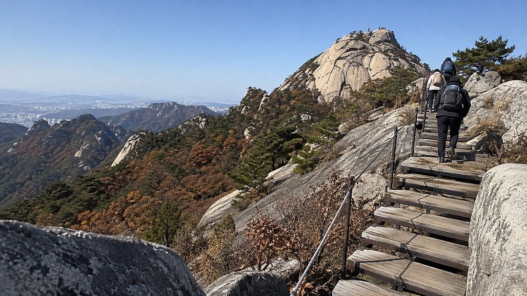
- From Ui-dong (east) – the park service’s standard Baegundae course. From the bus terminus in Ui-dong, walk about 2 km up a paved road past the Doseonsa temple approach to the Baegundae Trail Support Center. From there the trail climbs over Haru-jae pass, past Insu shelter and the Baegundae shelter, then through the old fortress gate Baegunbongammun (also called Wimun) to the top: 1.9 km and around 1.5 hours one way. The route passes beneath Insubong, a sheer granite dome next to Baegundae.
- From Bukhansanseong (west) – starting at the Bukhansanseong trailhead, this route passes the fortress gate Daeseomun and the temple Borisa before climbing to the summit; about 3.4 km and roughly 2 hours 40 minutes one way.
Both routes are rocky, and the last 0.5 km below the summit is steep, with cables and steps fixed into the rock. A Korean flag flies on the summit rock, and the view takes in Seoul and much of Gyeonggi Province at a glance.
Rules and safety
Korean national parks control trail entry by time. For the Baegundae route you may start from 04:00, but the control point closes at 17:00 from March to November and at 16:00 from December to February. Staying on the mountain after dark is not allowed, and areas off the marked trails around Baegundae are closed because of fall risk. At weekends the narrow summit section can back up badly, so start early and allow for delays. Bring water, proper boots and, from late autumn, microspikes or crampons.
Bukhansanseong Fortress
The ridges are threaded with the walls and gates of Bukhansanseong, a mountain fortress whose history the park service traces back some 2,000 years to the Three Kingdoms period, and the park holds around a hundred temples and hermitages. Combining a hike with Seoul’s palaces on another day gives a good sense of how the Joseon capital was defended.
Getting there
Both trailheads are reached by subway plus a short bus ride from central Seoul; see our transportation guide for using a transport card on buses. On a clear day you can also pick out the park’s peaks from the observatory at Lotte World Tower.
Frequently asked questions
How long does it take to climb Baegundae?
From the Baegundae Trail Support Center above Doseonsa the official route is 1.9 km one way and takes about 1.5 hours up, but add roughly 2 km of road walking from the Ui-dong bus terminus. The longer route from the Bukhansanseong trailhead on the west side is about 3.4 km one way and takes around 2 hours 40 minutes.
Is there an entrance fee for Bukhansan?
No. Entry to Bukhansan National Park is free; you pay only for parking if you drive to a trailhead with a paid car park.
Is there a time limit for starting the hike?
Yes. Under the national park entry-time system you may start up the Baegundae trail from 04:00, and you must pass the control point by 17:00 from March to November or by 16:00 from December to February. Plan to be off the mountain before sunset.
Is the Baegundae summit difficult?
The trail is moderate until the Baegundae shelter, then becomes short but very steep on bare granite, with steel cables and steps to hold. Wear proper hiking boots, and in winter carry crampons because icy stretches are common.
Sources
Facts on this page were checked against these sources on 2 October 2026. Prices, hours and rules change — confirm with the operator before you go.
- Korea National Park Service – Entry-time system (입산시간지정제) (Korean) · official
- Korea National Park Service – Bukhansan National Park: courses, transport and park information (Korean) · official
- Korea National Park Service – Notice: Baegunbongammun–Baegundae summit section reopened from 2 October 2026 (Korean) · official
- Seoul Mediahub – 서울이 발 아래, 세계인이 감탄하는 '북한산 백운대' 산행기 (Korean) · official
- Visit Seoul – Bukhansan National Park · official
- Kyunghyang Shinmun – national park entrance fees abolished (2007) (Korean)
- OpenStreetMap – Bukhansan (Baegundae) summit (coordinates)