Gwangju · Songjeong, Mudeungsan and Damyang
Mudeungsan National Park 무등산국립공원
The mountain on the city's edge, with the columnar rock pillars of Seoseokdae and Ipseokdae; a UNESCO Global Geopark.
Updated
Essentials
- Hours
- Trail entry windows (all trailheads): 04:00–16:00 December–February, 04:00–17:00 March–November
- Closed
- No closing day. On 16 November 2026 the park service's live closure board showed no autumn fire-season closure at Mudeungsan (most other parks closed their high trails on 15 November). Three sections ending at Wonhyo Square, on the Wonhyosa side, have been closed since 10 May 2026 for demolition work, with no reopening date: Eoksae Pyeongjeon–Wonhyo Square (3 km), Pungamjeong–Wonhyo Square (2.2 km) and the iron-smelting site–Wonhyo Square (0.6 km). Weather warnings can close any trail.
- Admission
- Park entry: free
- Getting there
- Jeungsimsa side (city side): bus 09 from U-Square bus terminal or Culture Center (Munhwajeondang) Station, every 10–20 min; 98 and 98-1 from Gwangju Songjeong KTX Station, every 20–28 min each; 54, 01, 56 and 170 also end there. All stop at the terminus 무등산국립공원(증심사)
- Subway: Line 1 to Hakdong·Jeungsimsa-ip, then any of the buses above from exit 1 or 2 to the terminus
- Wonhyosa side (north): bus 1187 from U-Square, Gwangju Station or Geumnamno 4-ga Station to 무등산국립공원(원효사), every 33–39 min, last departure 21:40
- Address
- 20 Jeungsimsa-gil, Dong-gu, Gwangju (Jeungsimsa bus terminus and trailhead)
전남광주통합특별시 동구 증심사길 20 - Website
- knps.or.kr/front/portal/visit/visitCourseMain.do?parkId=122000&menuNo=7020090
Book your trip
Mudeungsan National Park is free and sits on the eastern edge of Gwangju, with city buses running to two trailheads. Most people come to see Seoseokdae and Ipseokdae, walls of tall rock columns just below the summit. From the Jeungsimsa bus terminus the park service’s main route reaches them in 6.8 km and about 3½ hours one way. On 16 November 2026 Mudeungsan had no autumn fire-season closure, unlike most Korean parks; only three trail sections into Wonhyo Square on the north side are shut.
| Your situation | Do this |
|---|---|
| First visit, fit, one day | Jeungsimsa → Jungmeorijae → Jangbuljae → Ipseokdae → Seoseokdae, back down via Jungbong; allow most of the day |
| Easy half-day walk | Jeungsimsa → Dangsan tree → Jungmeorijae: 4 km, 1 h 35 min up, open views over the city |
| Arriving at Gwangju Songjeong (KTX) | Bus 98 or 98-1 from exit 1 straight to the Jeungsimsa terminus |
| Arriving at U-Square bus terminal | Bus 09 to Jeungsimsa (every 10–20 min), or 1187 to Wonhyosa |
| Here 15 November – 15 December 2026 | Mudeungsan is a good choice: the main trails stay open while other parks close their high routes |
| Want the true summit | Not possible on a normal day; Cheonwangbong is inside a military base. Walk to Inwangbong instead |
Is Mudeungsan worth it?
Yes, if you have a spare day in Gwangju and like hiking. Mudeungsan is a big, rounded mountain rather than a jagged one, but its upper slopes hold some of Korea’s finest columnar jointing: grey, many-sided stone pillars formed as thick volcanic flows cooled and cracked. The bus ride from downtown takes about 30 minutes, so it is one of the easiest national-park climbs to reach from a big city outside Seoul.
It suits people with a full day and some fitness: the routes are rated moderate, and the last stretch up to Jangbuljae is steep. If you only have a morning, the walk to Jungmeorijae gives a good view of the city and the upper mountain.
| Admission | Free |
| Main trailheads | Jeungsimsa (Dong-gu, city side); Wonhyosa (Buk-gu, north side) |
| Highest point | Cheonwangbong 1,187 m (military zone, normally closed) |
| Must-see | Seoseokdae and Ipseokdae rock columns, Natural Monument since 2005 |
| Autumn 2026 closure | None at Mudeungsan on 16 Nov; Wonhyo Square sections closed for works |
| Time to allow | Half a day to Jungmeorijae; a full day to Seoseokdae |
Courses, entry hours and closures from the Korea National Park Service’s Mudeungsan pages and live closure board; bus routes from Gwangju’s bus information system. All checked 16 November 2026.
Mudeungsan became a provincial park in 1972 and Korea’s 21st national park on 4 March 2013. It covers 75.4 km² across Gwangju and the Hwasun and Damyang counties. The wider area is a UNESCO Global Geopark, first certified in 2018 and renewed in 2023 and again in April 2026, according to Gwangju city as reported by the local press.
Is Mudeungsan open in November and December 2026?
Yes. Korea’s national parks close their high, fire-prone trails each autumn, and in 2026 most did so from 15 November to 15 December. On 16 November 2026 the park service’s live closure board showed no fire-season closure at Mudeungsan. The East office (the Hwasun and Damyang side) was listed as normal, and the main office still showed only its May 2026 notice. Korean tourism data says the park can close some sections between 1 November and 15 December, so check the live closure board (Korean) on the day.
The one standing closure is on the Wonhyosa side. Since 10 May 2026 the park has closed three sections that end at Wonhyo Square while the old shops of the Wonhyosa park village are demolished:
- Eoksae Pyeongjeon (the silver-grass plain) → Wonhyo Square, 3 km
- Pungamjeong pavilion → Wonhyo Square, 2.2 km
- The iron-smelting site → Wonhyo Square, 0.6 km
They stay closed until the demolition is finished; no date has been announced. Bus 1187 still runs to the Wonhyosa terminus, but first-timers are better off starting from Jeungsimsa. Entering a closed trail is fined under the Natural Parks Act. For how closures work across the country, see Korea’s national parks.
Which route to Seoseokdae and Ipseokdae?
All the classic routes meet at Jangbuljae, a broad saddle at the foot of the rock columns. From there a wooden boardwalk climbs 0.9 km (about 30 minutes) past Ipseokdae to Seoseokdae. Ipseokdae is a cluster of standing columns; Seoseokdae is a long cliff of them, with Gwangju spread out below. Distances and times below are the park service’s, one way:
| Route | Distance | Time | What it is like |
|---|---|---|---|
| Dangsan tree route: Jeungsimsa car park → Dangsan tree → Jungmeorijae | 4 km | 1 h 35 min | The most popular start; steady climb to a bare, open saddle |
| Saeinbong route: Jeungsimsa → Saeinbong → Seoinbong → Jangbuljae → Seoseokdae | 6.8 km | 3 h 30 min | Ridge walk with city views; a few exposed rocky spots, no water source |
| Neutjae–Old Road loop from Wonhyosa | 10.4 km loop | 4 h 50 min | Via Neutjae and Jangbuljae, back on the Old Road; check the Wonhyo Square closures first |
| Simujigi Falls traverse: Jeungsimsa → Tokkideung → Jangbuljae → Gyubong → Ingye-ri (Hwasun) | 15.2 km | 5 h 35 min | Crosses the mountain to a waterfall on the far side; you need transport back |
| Dowon village → Gyubong (Hwasun side) | 7.5 km | 4 h 30 min | Quieter east side, past the Gyubong rock columns; needs a car or taxi |
From Jungmeorijae the path climbs steeply via the Yongchu junction to Jangbuljae; the junction–Jangbuljae stretch alone is 0.6 km and 15 minutes. Most hikers go up one way and down another, for example up via Jungmeorijae and down via Jungbong to Jeungsimsa. The park says the Saeinbong ridge has no spring, so carry water.
On the Hwasun side, the trail from the Suman trail centre to the Jangbuljae junction (1.2 km) reopened on 12 September 2026 after repair work. It is the shortest way to the columns if you have a car.
Can you reach the summit?
Not on a normal day. The top three rock knolls, Cheonwangbong (1,187 m), Jiwangbong and Inwangbong, have been inside a military air-defence base since 1966.
- Inwangbong has been open to the public every day since 23 September 2023. A path of about 390 m (return) leads from Seoseokdae past the base’s rear gate to a viewing deck. It can close in strong wind.
- Cheonwangbong and Jiwangbong open only on occasional event days run by Gwangju city. The latest was 9 October 2025, the first in two years. Reports on that event said a photo ID was required and foreign nationals were not admitted because the summit is a military facility.
For most visitors, Seoseokdae plus the short walk to Inwangbong is the real high point.
Trail entry hours
Every Mudeungsan trailhead stops letting hikers in at a set time:
| Season | Entry allowed |
|---|---|
| December–February | 04:00–16:00 |
| March–November | 04:00–17:00 |
Start early. In November and December sunset is around 17:30, and a return trip to Seoseokdae takes most of the day. There is no bookable shelter on the mountain, so plan every route as a day hike. Gear and etiquette are on hiking in Korea.
Getting there by bus
Gwangju reorganised its city bus routes on 31 October 2026. The details below come from the city’s bus information system, checked 16 November 2026. Route numbers can change again as the city adjusts the new network, so check KakaoMap or Naver Map before you go.
| Bus | To | Where to board | Every | First–last |
|---|---|---|---|---|
| 09 | Jeungsimsa | U-Square terminal, Geumnamno 4-ga, Culture Center Station | 10–20 min | 05:40–22:30 |
| 98 / 98-1 | Jeungsimsa | Gwangju Songjeong Station exit 1, Gwangju Station, Culture Center Station | 20–28 min each | 05:40–22:20 |
| 54 | Jeungsimsa | Namgwangju Station | 6–9 min | 05:40–22:40 |
| 01 | Jeungsimsa | U-Square terminal | 16–22 min | 05:40–22:20 |
| 1187 | Wonhyosa | U-Square terminal, Gwangju Station, Geumnamno 4-ga Station | 33–39 min | 06:20–21:40 |
First and last times are departures from each route’s starting point. Routes 56 and 170 also end at the Jeungsimsa terminus.
Subway option. Gwangju Metro Line 1 stops at Hakdong·Jeungsimsa-ip Station. From exit 1 or 2, any of the Jeungsimsa buses above covers the last few kilometres up the valley to the terminus, 무등산국립공원(증심사).
From Seoul. The KTX from Yongsan to Gwangju Songjeong takes about 1 h 40 min – 2 h; see getting to Gwangju. By express bus from Seoul’s Central City terminal to U-Square and then bus 09, the park service puts the whole trip at about 4 hours.
When to go
Late October to mid-November is the best time, with autumn colour on the lower slopes and silver grass on the Jangbuljae plain. In 2026 the park also stayed open after 15 November, when most others closed. Spring brings azaleas and summer is hot and humid; the park lists cooling shelters and routes to avoid in heatwaves. Winter frosts the rock columns and the summit ridge, but the upper paths ice over, so bring crampons. For the season in general, see autumn leaves in Korea.
Around Mudeungsan
Combine an easy morning on the mountain with downtown Gwangju: the Asia Culture Center and the former South Jeolla Provincial Office are on the same bus 09 route. For a flat walk instead of a climb, take bus 311 to Damyang’s bamboo forest, Juknokwon. The Gwangju guide covers the rest of the city, and the Jeolla region guide the surrounding province.
Nearby
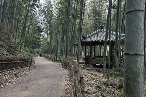
Juknokwon (Damyang)
Damyang's bamboo forest park, 2.4 km of shaded trails for ₩3,000, open every day; a half-day trip from Gwangju on bus 311.
May 18th National Cemetery
The national cemetery for those killed in the uprising, with a memorial tower and exhibition hall; open daily, bus 518.
Yangnim-dong Penguin Village
Alleys hung with old clocks, signs and scrap art, now a craft street; free, shops closed Mondays.
Asia Culture Center (ACC)
A huge sunken arts complex with exhibitions, theatres and a free Asian Culture Museum; closed Mondays.
Frequently asked questions
Is Mudeungsan open in November and December 2026?
Yes. On 16 November 2026 the national park service's live closure board listed no fire-season closure at Mudeungsan, while most other parks shut their high trails from 15 November to 15 December. The only standing closure is three trail sections into Wonhyo Square on the north side. Check the board on the day, as weather warnings close trails at short notice.
What is the easiest way to see Seoseokdae and Ipseokdae?
Start at the Jeungsimsa bus terminus. The park service's main route over Saeinbong reaches Seoseokdae in 6.8 km and about 3½ hours one way; the valley route via the Dangsan tree reaches Jungmeorijae in 4 km and 1 h 35 min, then climbs steeply to Jangbuljae. From Jangbuljae it is 0.9 km and 30 minutes on a boardwalk past Ipseokdae to Seoseokdae.
Can you climb to the summit of Mudeungsan?
Only partly. The top, Cheonwangbong (1,187 m), and its neighbour Jiwangbong sit inside a military base and open only on occasional event days. The third summit rock, Inwangbong, has been open every day since 23 September 2023, a short walk from Seoseokdae. Reports on the October 2025 event said foreign nationals were not admitted.
How do I get to Mudeungsan from Gwangju Songjeong Station?
City buses 98 and 98-1 run from Gwangju Songjeong Station (exit 1) through downtown to the Jeungsimsa terminus, each every 20–28 minutes by the city's bus information system. From U-Square bus terminal, take bus 09 instead. For the Wonhyosa side, take bus 1187 from U-Square or Gwangju Station.
Is there an entrance fee for Mudeungsan National Park?
No. Korean national parks charge no admission. You pay only for parking if you drive; the park service does not publish the parking fee on its page.
Sources
Facts on this page were checked against these sources on 16 November 2026. Prices, hours and rules change — confirm with the operator before you go.
- 국립공원공단 – 무등산국립공원 (2013년 3월 21번째 국립공원, 75.425㎢, 해발 1,187m, 서석대·입석대·광석대 주상절리) (Korean) · official
- 국립공원공단 – 무등산 공원안내·연혁 (1972.05.22 도립공원, 2013.03.04 국립공원 제21호; 경관자원 145개소, 생물종 4,066종) (Korean) · official
- 국립공원공단 – 무등산 탐방코스 (새인봉-입석대 6.8km 3시간30분; 당산나무 4km 1시간35분; 늦재-옛길 10.4km; 시무지기폭포 15.2km 5시간35분; 도원마을-규봉 7.5km 4시간30분; 입석대·서석대 2005년 천연기념물) (Korean) · official
- 국립공원공단 – 무등산 교통편 안내 (광주종합버스터미널→증심사지구 09번 30분, 원효사지구 1187번 30분) (Korean) · official
- 국립공원공단 – 입산시간지정제 (무등산 탐방로별 동절기 12~2월 04:00~16:00, 하절기 3~11월 04:00~17:00) (Korean) · official
- 국립공원공단 – 탐방로 통제 정보 (2026-11-16 기준: 무등산 부분통제 2026-05-10, 무등산동부 정상) (Korean) · official
- 국립공원공단 – 무등산 원효사공원마을지구 철거·정비사업 관련 탐방로 부분통제 (억새평전~원효광장 3km, 풍암정~원효광장 2.2km, 제철유적지~원효광장 0.6km) (Korean) · official
- 국립공원공단 무등산동부 – 수만탐방지원센터~장불재갈림길 탐방로 개방 안내 (2026-09-11; 9.12. 개방) (Korean) · official
- 광주 버스정보시스템 – 노선검색 (01·09·54·56·98·98-1·170 무등산국립공원(증심사), 1187 무등산국립공원(원효사); 첫차·막차·배차간격; 2026-11-16 조회) (Korean) · official
- K-TRIP TIPS (한국관광공사 데이터) – 무등산국립공원 (입장료 무료, 연중무휴, 하절기 04:00~17:00·동절기 04:00~16:00; 2026-11-11 갱신) (Korean)
- 트윅24 – 무등산 정상, 57년 만에 시민 품으로 (2023-09-25; 9월 23일부터 인왕봉 상시 개방, 서석대~인왕봉 전망대 왕복 390m) (Korean)
- 트윅24 – 무등산권 유네스코 지질공원 3연속 인증 (2026-04-28; 2018 최초 인증, 2023·2026 재인증; 광주·전남·담양·화순 공동 운영) (Korean)
- 트윅24 – 무등산국립공원 원효계곡 일대 상가 철거 본격화 (2026-05-12; 원효광장 연결 3구간 철거 완료 시까지 통제) (Korean)
- 서울신문 – 무등산 정상 2년 만에 개방… 3000명 가을 만끽 (2025-10-10; 1966년부터 군부대로 출입 통제) (Korean)
- 다음 여행 채널 – 무등산 정상 2025년 10월 9일 개방 안내 (신분증 필수, 외국인 출입 제한, 인왕봉 상시 개방) (Korean)