Jeju Island · Seogwipo and Jungmun
Jeju Olle Trail 제주올레길
A long-distance walking route circling the island in numbered day-length courses; the Seogwipo sections are favourites.
Updated
Essentials
- Hours
- The trail is open at all times; the Jeju Olle Foundation asks walkers to finish by 18:00 in summer and 17:00 in winter
- Jeju Olle Tourist Center (start of Route 7): 08:30–17:30, lunch break 12:00–13:00
- Closed
- Tourist Center and official information centres close on the day of Seollal (Lunar New Year) and Chuseok
- Admission
- Walking the trail is free
- Jeju Olle Passport (stamp book, paper or mobile): 20,000 won
- Certificate of completion for all 27 routes: 5,000 won issuance fee
- Getting there
- Route 7 starts at the Jeju Olle Tourist Center in central Seogwipo; airport limousine 600 to 샛기정공원 (Saetgijeong Park), 26 stops, then about 100–170 m
- Route 7 ends at Seogwipo Bus Terminal, by the 제주월드컵경기장(600번) stop of the same limousine
- Address
- Jeju Olle Tourist Center, 22 Jungjeong-ro, Seogwipo-si, Jeju
제주특별자치도 서귀포시 중정로 22 (제주올레 여행자센터) - Website
- jejuolle.org/trail_en
Book your trip
The Jeju Olle Trail is free and open at all times: 27 waymarked routes, 437 km in total, circling Jeju and three of its small islands. Each route is a day walk of about 4–20 km. For a first walk, take Route 7 in Seogwipo: 12.9 km, 3–4 hours, with an airport bus at both ends. Finish by 17:00 in winter, 18:00 in summer.
“Olle” is the Jeju word for the narrow stone-walled lane that leads from the street to a house. The trail strings such lanes together with coastal paths, oreum (small volcanic cones), forests and farm roads. It is run by the non-profit Jeju Olle Foundation, which recommends walking one route a day at your own pace; at about 3 km an hour, that adds up to roughly a month for the whole circuit.
Which Olle route should you walk?
Most visitors walk one route, or part of one, on a single day. Pick by where you are staying and how much of the day you want to give it.
| Route | From – to | Length | Time | Why pick it |
|---|---|---|---|---|
| 7 | Jeju Olle Tourist Center – Seogwipo Bus Terminal | 12.9 km | 3–4 h | Oedolgae sea stack, the Subong-ro cliff path, lunch at Beophwan port; buses at both ends |
| 6 | Soesokkak – Jeju Olle Tourist Center | 10.1 km | 3–4 h | Soesokkak estuary, coast and town walking past Jeongbang Falls and the Maeil Olle Market |
| 10-1 | Gapado island loop | 4.2 km | 1–2 h | Flat, very short walk on a low island off the south-west coast; reached by ferry |
| 14-1 | Jeoji – Seogwang (O’sulloc) | 9.3 km | 3–4 h | Gotjawal forest and Mundo-ji Oreum, ending at the O’sulloc tea fields |
| 1 | Siheung – Gwangchigi | 15.1 km | 4–5 h | The first route: Malmi and Al oreum with views of Seongsan Ilchulbong and Udo |
| 10 | Hwasun – Moseulpo (Hamo) | 15.6 km | 5–6 h | Coastal walk under Sanbangsan and past Songaksan, with Gapado and Marado offshore |
| 8 | Wolpyeong – Daepyeong | 19.3 km | 5–6 h | Passes Jusangjeolli Cliff and Yerae Ecological Park |
| 21 | Hado – Jongdal | 11.3 km | 3–4 h | Farm roads, coast and Jimibong peak at the island’s eastern end |
Lengths, times and highlights from the Jeju Olle Foundation’s route pages (Korean and English versions agree), checked 23 October 2026. If you only have half a day, walk the first part of Route 7 from the Tourist Center to Oedolgae and Beophwan port and take a bus back. Walkers who are used to it can join Routes 6 and 7, which meet at the Tourist Center.
The official pages also rate difficulty, but the ratings shown on the English and Korean pages do not match for several routes, so they are left out here. Use length and time instead.
The island routes
Three routes are on smaller islands and need a ferry: 1-1 on Udo (13.2 km, 4–5 h), 10-1 on Gapado (4.2 km, 1–2 h), and 18-1 and 18-2 on the Chuja Islands (11.4 km and 9.7 km). Check ferry times before you plan a day around them.
Route 7: the classic first walk
Route 7 runs west along Seogwipo’s coast from the Jeju Olle Tourist Center to the bus terminal in the new town. Soon after the start it reaches Oedolgae, a 20 m rock pillar standing alone in the sea, and the cliff-top Dombe-nang-gil, with views of the islets Munseom, Saeseom and Beomseom. Subong-ro is a stretch of steps and path cut by hand with a shovel and pickaxe in 2007 along a route goats used. At Beophwan port there are restaurants and cafes by the sea, a natural lunch stop.
The route has no wheelchair-accessible section, by the foundation’s own listing.
Getting to the start and back
The foundation’s advice is to put the start or finish point into Kakao Map or Naver Map for live bus times, and to use public transport rather than a rental car, as parking at start points is limited.
| Route point | Bus | Stop |
|---|---|---|
| Route 7 start (Tourist Center) | Airport limousine 600 (600-1) from the 600 stop at Jeju Airport, 26 stops | 샛기정공원 (Saetgijeong Park), about 100–170 m away |
| Route 7 finish (Seogwipo Bus Terminal) | Limousine 600 back to the airport (600-2), 25 stops; or express 182 from the 제주월드컵경기장 서귀포버스터미널 stop next to the terminal | 제주월드컵경기장 (World Cup Stadium) |
| Route 6 start (Soesokkak) | Buses 520, 623, 624 | 쇠소깍 입구 (Soesokkak Entrance), about 250 m |
| Route 1 start / finish | Bus 201 along the east coast (a long ride from Jeju Bus Terminal) | 시흥리 (Siheung-ri) / 광치기해변 (Gwangchigi Beach) |
| Route 10 start | Local buses 752-1, 752-2 | 화순금모래해수욕장 (Hwasun Golden Sand Beach) |
| Route 10 finish | Express 102 (13 stops) or 151 to the airport | 하모체육공원 (Hamo Sports Park) |
Stop orders from the Jeju Bus Information System; distances are straight-line from the official start and finish coordinates, checked 23 October 2026. The limousine leaves from its own 600 stop at the airport, and the airport stop on the way back is drop-off only. A T-money card works on island buses. For taxis, the route pages list Seogwipo call-taxi numbers such as 064-762-0100.
Waymarks, passport and certificate
You do not need a map to stay on the trail. Look for:
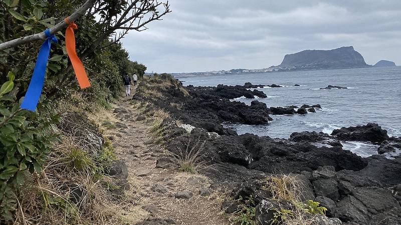
- Ribbons: a blue and an orange ribbon tied together on poles and branches.
- Arrows: blue arrows point the way for walkers going in the official direction, orange for walking in reverse.
- Ganse: a pony-shaped marker at junctions; its head points the way.
- Distance plates: 16 cm square plates showing the distance walked and the route total.
If you lose the waymarks, go back to the last one you saw and look again. Detours are signposted with two orange ribbons. Free route maps are on the foundation’s website, and the information centres give out a free guidebook in English, Chinese and Japanese.
The Jeju Olle Passport (20,000 won) is a passport-sized stamp book with route maps; a mobile version in the Olle Pass app costs the same. The two cannot be combined. Each route has stamp boxes at the start, middle and finish. Walk all 27 routes, stamping every box, and the Tourist Center issues a certificate and medal (issuance fee 5,000 won; 09:00–11:30 and 13:00–16:30). For routes split into A and B (3 and 15), either version counts. Paper passports are sold at the Tourist Center and the route information centres.
Safety rules and what to bring
- Finish in daylight. The foundation asks walkers not to walk after 18:00 in summer or 17:00 in winter, and not to walk in typhoons, heavy rain or snow.
- Walking alone? Call the Jeju Olle call centre on 064-762-2190 when you set off, tell someone your plans and keep phone location services on. Police: 112.
- Ticks. Wear long sleeves and trousers, even in summer, use repellent and do not sit directly on grass. See a doctor if you get a fever within two weeks of a walk.
- Bring water and cash. Shops are sparse on many routes and not all accept cards; keep some cash for a taxi.
- Shoes. Trekking shoes are best; non-slip trainers are fine for a single short route.
- No disposables. The trail discourages single-use cups and chopsticks, and you carry your rubbish out.
- Check notices. Temporary detours are posted on the foundation’s notice board before you set off.
The free Walking Mate program sets off every week at 09:30 with local volunteer guides speaking English, Chinese, Japanese or other languages, depending on who is available. Sign up in the Olle Pass app under Program Registration.
Around the Olle Trail
Route 6 passes Jeongbang Falls and Cheonjiyeon Falls is a short walk from the Tourist Center, so a Seogwipo day can combine a morning on Route 7 with the waterfalls in the afternoon or evening. The trail also runs past Hyeopjae Beach (Route 14), Hamdeok Beach (Route 19); Routes 17 and 18 meet at the Kim Man-duk Memorial Hall in Jeju City. For more walks around Korea, see hiking in Korea; for flights, buses and where to stay in Seogwipo, see the Jeju guide and the Jeju region page.
Nearby
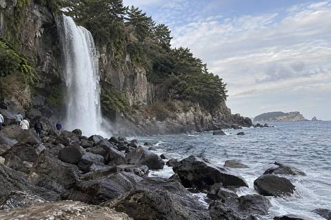
Jeongbang Falls
A waterfall that drops straight onto a rocky beach and into the sea, a rarity in Asia.
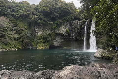
Cheonjiyeon Falls
A waterfall in a lush subtropical gorge reached by a flat walk, also popular in the evening.
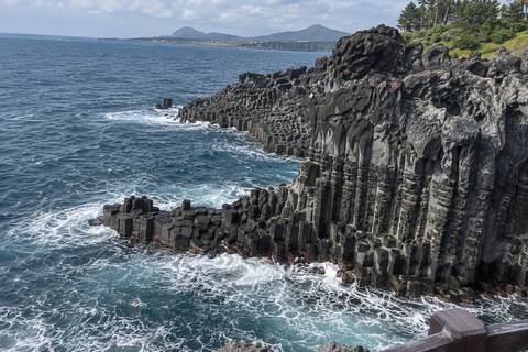
Jusangjeolli Cliff
Columns of hexagonal basalt stacked along the shore near Jungmun, pounded by surf.
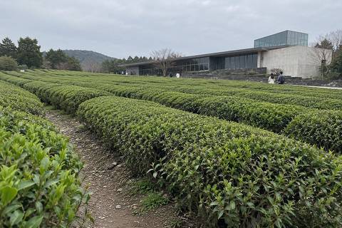
O'sulloc Tea Museum
A modern tea museum and cafe beside rolling green tea fields, known for green tea desserts.
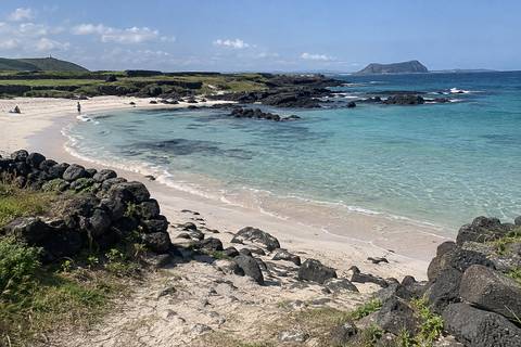
Udo
A small island 15 minutes by ferry from Seongsan, with white beaches and a grassy headland; most rental cars can't go.
Frequently asked questions
Which Jeju Olle route is best for a first walk?
Route 7 is the usual first choice: 12.9 km, about 3–4 hours, from the Jeju Olle Tourist Center in Seogwipo past the Oedolgae sea stack and the Subong-ro cliff path to Seogwipo Bus Terminal. Both ends are on the airport limousine 600, so you need no car.
How long is the Jeju Olle Trail?
The trail has 27 routes with a total length of 437 km. Most routes are 10–20 km and take 3–7 hours; the shortest, Route 10-1 on Gapado island, is 4.2 km. The Jeju Olle Foundation recommends one route per day, which makes about a month for the whole trail.
Is the Jeju Olle Trail free?
Yes. Walking any route is free and needs no booking. The optional Jeju Olle Passport stamp book costs 20,000 won (paper or in the Olle Pass app), and the certificate for finishing all 27 routes has a 5,000 won issuance fee.
Can I walk the Olle Trail alone without a guide?
Yes. The routes are waymarked with blue and orange ribbons, arrows and pony-shaped markers. The foundation asks solo walkers to call 064-762-2190 when they set off, keep phone GPS on and finish by 18:00 in summer or 17:00 in winter. A free weekly guided walk in foreign languages, Walking Mate, is booked in the Olle Pass app.
How do I get to the start of an Olle route by bus?
Look up the start point in Kakao Map or Naver Map, as the foundation advises. For Route 7, take the airport limousine 600 to 샛기정공원 (Saetgijeong Park), 26 stops, a short walk from the Tourist Center. Route 1 is on bus 201 along the east coast, and Route 10 ends at 하모체육공원 on express buses 102 and 151.
Sources
Facts on this page were checked against these sources on 23 October 2026. Prices, hours and rules change — confirm with the operator before you go.
- 제주올레 – 코스 안내 (27코스 437km; 코스별 총 길이·소요시간·시작점·종점; 7코스 여행자센터–서귀포버스터미널 12.9km 3-4시간) (Korean) · official
- Jeju Olle Trail – Routes, FAQ and Walking Mate (English; GPS start/finish points, hiking hours, passport, certificate fee 5,000 won) · official
- 제주올레 – 여행준비 (길 표식, 준비물, 패스포트 20,000원) (Korean) · official
- 제주올레 – 올레센터 (제주올레 여행자센터 08:30~17:30, 점심 12:00~13:00, 설·추석 당일 휴무; 완주증 발급 시간; 코스별 공식 안내소) (Korean) · official
- 제주올레 – 올레길 안전수칙 안내 (하절기 18시·동절기 17시 이후 걷기 자제, 혼자 걸을 때 콜센터 064-762-2190 연락, 야생진드기) (Korean) · official
- 제주버스정보시스템 – 600번 리무진(제주국제공항 ↔ 샛기정공원·제주월드컵경기장), 201번, 102·151번 급행 노선 정류소 목록 및 정류소별 경유 노선 (Korean) · official